Executive Summary
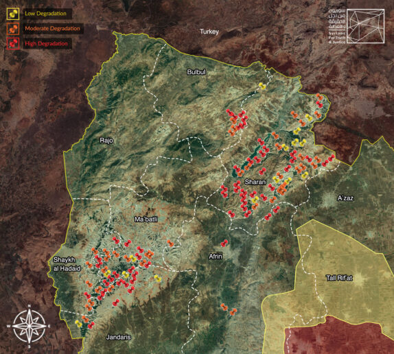
In this report, Syrians for Truth and Justice (STJ) and Lêlûn Association for Victims in Afrin reveal illegal logging operations in 114 forest sites in Syria’s Kurdish-majority region of Afrin. Based on the extent of the concentration of tree-cover loss, STJ monitored:
- High degradation of the forests in (57) locations, where perpetrators cleared the forests almost trees entirely.
- Moderate degradation of the forests in (42) locations.
- Low degradation of forests in (15) locations.
Notably, there are no official statics on the number of trees cut since 2018. However, STJ estimates the loss at tens of thousands, while several local sources that STJ met with for this report insist that the number is higher, verging on hundreds of thousands.
STJ has been keeping close tabs on forest logging across the Afrin region since late 2019. Field researchers monitored large-scale woodcutting in several of the region’s forest areas. To verify the logging activities the researchers recorded, STJ talked to sources informed of the situation, compiled evidence from various open sources, analyzed the collected information, and matched the findings with satellite images.
In terms of methodology, this report draws on accounts STJ obtained through direct interviews, in person and online, with local sources and witnesses in the affected areas, in addition to visual evidence and information available in open sources that addressed the report’s subject matter. For further verification, STJ matched the collected data with satellite imagery, which provided overwhelming evidence of the rampant clearing of forests in the region after the Turkish military and affiliated Syrian armed opposition groups controlled Afrin following the 2018 Operation Olive Branch. Notably, several international independent organizations and UN bodies label the Turkish military’s presence in the region as an occupation.
STJ carried out 36 interviews over the past months. The interviewees included several locals, internally displaced persons (IDPs), members from the opposition’s Syrian National Army (SNA), relief workers, one of whom reported that his organization purchased logs harvested in Afrin, and two timber merchants in Northern Syria, who are familiar with timber trafficking routes and markets. Following the interviews, STJ thoroughly analyzed the accounts the field researchers obtained from the sources and the footage they collected from the cleared sites. Based on the analysis, the digital forensic expert with STJ demarcated the locations most affected by illegal logging and matched them with as many as (72) satellite images to identify the extent of tree-cover loss in the deforested areas.
Afterward, the digital forensic expert matched the satellite images with live footage (taken directly of the targeted forests or screenshots from available videos) to mark the exact locations of these sites and corroborate logging. Furthermore, the digital forensic expert obtained additional evidence, verifying that the perpetrators had cut down thousands of trees in over 15 other locations through compiling online footage, data from open sources, and conducting comparisons of satellite imageries of the region from various dates.
Notably, STJ has designated this report solely to illegal logging and subsequent deforestation in the Afrin region, intending to publish a separate and extensive piece on the illicit clearing of olive orchards belonging to the region’s indigenous population.
In the map below, STJ locates the verified sites of illegal logging in the Afrin region, which amounted to 114. Importantly, STJ is confident that the actual number of affected forest patches across Syria is higher than the fraction the map exhibits.

Additionally, in the table below STJ lists some of the dominant plant species native of the Afrin region:[1]
|
# |
Species in Arabic |
Species in Kurdish |
Species in English |
|
1 |
البطم (al-Battim) |
Kewzan, Kizwan, Benîştokê |
Pistacia |
|
2 |
السنديان (ثمرها يُدعى بلوط) (Al-Sindyan which fruits is called balloutt) |
Kelem, Mazî, and Gêlberî. |
Oaks, which fruits are called acorns |
|
3 |
العرعر (Al-‘Arar) |
Guvîj |
Juniper |
|
4 |
الزيتون البرّي (Zaytoub Bari) |
– |
Wild Olives |
|
5 |
السمّاق (Sumaq) |
– |
Rhus |
|
6 |
العناب البرّي (al-‘Enab al-bari) |
Ti’ok |
Wild Jujube |
|
7 |
شكوكه (Shikoke) |
Şikoke |
Hawthorns |
|
8 |
هيلورشك (Hilroshik) |
Ĥiloreşk |
– |
|
9 |
تعوّي (Ta’wi) |
Te’wî |
– |
|
10 |
مرخ (Markh) |
Merx |
Leptadenia |
|
11 |
قطلب (Qattlab) |
Qetleb |
Arbutus |
|
12 |
نرمك (Narmik) |
Nermik |
– |
|
13 |
ايفرس (Evris) |
Êvirs |
– |
|
14 |
الدلب (al-Dalb) |
Çinar |
Platanus |
|
15 |
ديريرشك (يُصنع من جذورها الإمزك لتدخين السجائر). (Dirirshek) |
Dirîreşk أو Siĝirgotik |
– |
|
16 |
كنار (Kehnar) |
Kenar |
Ziziphus |
|
17 |
شرت (Shirt) |
Şirt |
– |
|
18 |
تزبي (Tizbi) |
Tizbî |
– |
|
19 |
سفتك (Siftak) |
Siftek |
– |
Deforestation and illegal logging adversely impact the environment, biodiversity, and communities in and around forest areas. Concerning the environment, the felling of trees obliterates a natural buffer zone that forests represent. Trees prevent soil erosion and floods and, most importantly, mitigate the risks of climate change, particularly spiking levels of carbon dioxide (CO2). Likewise, extensive logging has catastrophic repercussions for biodiversity. Deforestation threatens many animals and insects with extinction. The cut trees are habitats for a large and diverse number of animals, which enter into fierce competition for food after they migrate from their destroyed original habitats, becoming unable to reproduce.
However, the effects of deforestation remain the most harmful to the indigenous forest dwellers, threatening their lives in many ways. For example, animals and insects displaced from their habitats seek shelter in the inhabited villages surrounding the forests, which warrants unfamiliar contact between the people and wildlife. Moreover, this unprecedented interaction badly influences human health, because it is not only unnatural but also dangerous, creating fertile grounds for diseases.
Unabating logging also undermines the locals’ food security. Surrounding communities consider forests as direct and indirect sources of food. They harvest fruits, herbs, and other edible plants or cultivate crops using the forests’ fertile soil. Deforestation also threatens to displace locals, who either lose their food sources or livelihoods with the disappearing tree cover. The forests’ soil provides farmers with organic nutrients for the crops, while it provides shepherds with forage for their livestock.
Notably, this report, which focuses on the waning forests in the Afrin region, seeks to complement the tremendous documentation efforts of other local and international organizations in this domain, including the lengthy report PAX has recently published. In the report, PAX documented deforestation across Syria, including in the western part of the country. Located in that part, the provinces of Latakia, Hama, Homs, and Idlib lost over 36% of their tree cover between 2011 and 2021. Based on remote-sensing analysis, PAX discovered that in the four provinces, “[f]rom an initial cover of 1,230km2 in 2010, 12 per cent was lost by 2016 and another 24 per cent was lost by the end of 2021. This represents a total loss of 45,320 hectares of tree cover in this time frame.”
The organization also investigated forest batch disappearances in the Afrin region, particularly following the Turkish military and their affiliated armed groups’ incursion into the region in 2019. The report highlights that the military hostilities displaced civilian Kurds again. At the same time, a new wave of IDPs sought refuge in Afrin, coming from other Syrian territories. As a result, north of Afrin, “a small park overlooking the city largely disappeared, as IDPs built informal settlements and cut down the trees for firewood and housing. In a 27 hectare forest patch (in 2015 and 2018), around 43 per cent was deforested between 2018 and 2021. The 45 per cent at the top of the hill has deteriorated badly (and is hardly forest anymore), as has the patch at the south, representing the remaining 12 per cent.”
The organization obtained detailed figures on the extent of tree cutting in other areas in and near the Afrin region, particularly the Kurd Mountains and Mount Barsa. The report reveals that deforestation started in that territory two years after the Turkish-backed armed opposition groups established control there. With remote-sensing analysis, PAX documented “a 56 per cent loss in tree cover over the course of almost six years, largely through deforestation in this area, from an initial forest cover of 4,750 hectares in December 2015.”
You may read and download the full version of this report (73 pages) in PDF format by clicking here.
[1] Abdo, Muhammad Ali. Mount Kurd (Afrin): A Geographical Study (in Arabic). 2009. P. 14.

